 |
| Chipola Floodplain |
Click on a photo for a larger view, then scroll through the photos as you like. Return to the story by clicking outside the photo. I greatly appreciate all comments added below. Enjoy!
When most people think "west", the Florida Panhandle does NOT come to mind. As (mainly) a Florida photographer based near Tallahassee, my recent jaunts west have taken me to a few of our state's spectacular river ecosystems.
 |
| Indian Pink |
Tropical Storm Debby dumped 23 inches of rain in our yard over a 36 hour period this week, dramatically re-filling our drought-stricken rivers, wetlands, and aquifers. So as I post these photos from "the dry times," I am reminded of the cycles and fluctuations of nature, realizing that the rivers, floodplains and tributaries depicted here are now overflowing.
In the bigger picture, as our waters become progressively compromised by increasing demand, weakened protective laws and regulation, and added pollution, I recognize the preciousness and vulnerability of these pockets of beauty remaining in wilder parts of La Florida.
 |
| Florida Caverns |
The spring-fed Chipola River is one of my favorite streams, starting near Marianna and flowing south to finally spill into the Apalachicola River down in Gulf County. Near its origin, the river disappears into a cave system for a spell in the Florida Caverns State Park. Here the Chipola is lined with otherworldly karst features, spectacular floodplains, creeks and springs, and beautiful wildflowers. Crystal and I spent a couple days at Florida Caverns when the Indian Pinks were in full bloom, and left with a greater appreciation for the richness and diversity in the Park.
 |
| Oakleaf Hydrangea in Chipola Floodplain |
 |
| Cavern of Colored Lights |
 |
| "Mystic Springs" |
And we found one new spring run which we followed up to a small lovely clear springhead. Its water flowed bountifully over limestone shelves, creating ever-changing riffs of liquid light.
Paddling further upstream to "Mystic", we were surprised - AND RELIEVED, to find Mystic Spring flowing once more, apparently just very sensitive to the water table in the area. I was thrilled to find the spring healthy, as I consider it to be one of Florida's finest secret spots.
DDay became night as we paddled back down to Peacock Bridge... a glorious night with Venus and a crescent moon.
Hiking in the creekbed, I came to a section where the limestone walls towered over me and my pack brushed both sides nearly wedging me in. Wow. This is Florida!
Much further south, long after the Chipola has spilled its waters into the Apalachicola, the big river spreads broadly into marshlands, flowing into its estuary and bay at the Gulf of Mexico. Delivering clean freshwater so vital to the big sweet oysters that grow abundantly on the bars in the bay, one might not be aware that the headwaters of the Apalchicola up in Georgia are being extracted in ever-greater volume by ever-growing thirsty Atlanta. With flow depleted, the oysters and fisheries way down here on the coast have suffered, especially in drought times, and one day may altogether collapse.
For now, recreational and commercial fishing still thrive in the area. Florida Fish and Wildlife maintains a number of landings in the Apalachicola WEA which I was assigned to document in April. Some sites are simply boat ramps, while others have trails, viewing towers, and swimming holes.
 |
| Cash Creek |
 |
| Gardner Landing |
 |
| Sand Beach Tower - East Bay |
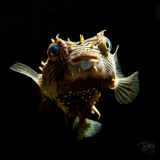
In Eastpoint, the Apalachicola National Estuarine Center is a new nature center designed to help visitors understand and help preserve Florida's natural wetlands. Being nearby, I stopped in for a delightful visit and came away with a photo of one cute little Striped Burrfish from nearby Apalachicola Bay.


6 comments:
Grace filled timing for this posting, David. You help me stay connected to beloved wildness. Wonder what Mystic Springs looks like this morning. Bless your dear heart.
Thank you so much!
These are some great shots, David. Florida is not the easiest place to practice your photography, but you have done well.
Glad to hear and see that Mystic has regained its groove. Great to have a virtual return trip to the Chipola after making its acquaintance in January.
Excellent work. I enjoy your captures of the Real Florida. I hope all is well after your deluge... It's heading down the Suwannee now and will crest near us soon...
Thanks to all of you. Greg, I enjoy your weekly photos a lot. We did fine in the storm, though our sinkhole rose over 8 ft (still up about 6). A LOT of much needed water fell on La Florida!
Post a Comment